Explore the East Bay | Bay Day 2021
Bay Day Regional Spotlight
Brought to you by Facebook, weekly regional spotlights give an in-depth look at the Bay Area. From trails and activities to inspire your Bay Day Trail Challenge adventures, to partners and locations vital to Save The Bay’s mission of creating a healthy and resilient Bay – discover what makes our region so special, and so important to protect.
Don’t forget to follow us on Instagram and Facebook and share your adventure with #BayTrailChallenge #SFBayDay and tag @saveSFbay for the chance to win a $50 REI gift certificate every week in October.
Discovery Guide
Trails
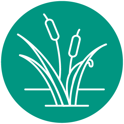
The Alameda and Oakland shorelines feature many beaches, historical sites, and nature trails, as well as the biggest active bay port. This trail begins in Alameda’s Towata Park and follows the city streets to the Oakland Waterfront Pathway, a 19-mile trail that ducks around urban areas, parks, and lakes. Smaller trails such as those between Fruitvale and High streets can be accessed via bike lanes and sidewalks along the Embarcadero. →
San Leandro to Bay Farm Island
The trail begins on the Hayward Regional Shoreline, which is full of pickleweed marshes, seasonal wetlands, and mudflats teeming with wading birds. The trail continues into San Leandro’s shoreline park, and eventually leads to the Tidewater Boating Center, where you can watch or participate in watersports such as kayaking and boating. At the Harbor Bay Isle Ferry Terminal, catch the Alameda Bay Harbor Ferry to San Francisco or explore Bay Farm Island. →
Activities
Pollinators are extremely important for the health of an ecosystem and are responsible for most of the food grown on farms. Connect with the Bay by growing plants pollinators love in your backyard. →
Our “Young Botanist” activity connects art with science, inviting participants to carefully observe, locate, and draw their own subjects. →
Hayward Shoreline
While exploring the Bay shoreline, notice all the ways that the landscape has been altered by development. In many parts of the Bay, we have built right up to the shoreline with houses, roads, and other critical infrastructure like water treatment plants. Much of this development is already in areas that are at risk of flooding, and in coming years that risk will increase and expand as sea level rise pushes the Bay shoreline upland. In an era of rising tides due to climate change, where we develop in the future and how we protect existing homes and infrastructure are some of the most pressing questions that Save The Bay is working to address.
Hayward is spearheading an approach that could serve as a model for the entire Bay Area. Earlier this year, the Hayward Shoreline Adaptation Master Plan was adopted between the City of Hayward, Hayward Area Recreation District, and the East Bay Regional Park District to prepare the area for rising tides. Importantly, this plan heavily relies on restoring tidal marsh and natural habitats and utilizes gradual sloping landscapes called ecotone levees. These types of levees absorb storm surges and allow shoreline habitat to migrate as seas rise while still providing needed flood protection for developed areas behind them.
Save The Bay has partnered with the Oro Loma Sanitary District to manage a horizontal levee that protects the wastewater treatment plant, and the concept has proven very successful. We are very excited that this plan will build on that initial pilot project, and restore several former salt production ponds into tidal marsh habitat that will also protect the surrounding community from flooding. The Hayward plan is proof that when jurisdictions work together, we can prepare our cities for sea level rise while also improving the health of the Bay, restore native habitat for endangered species, and expand recreational opportunities along the shoreline.
SF Bay Trail Birds
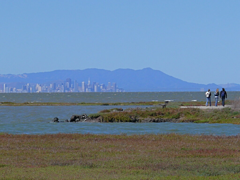
The San Francisco Bay Trail is a necklace of essential habitat for threatened bird species, including the Ridgeway’s Rail and the Western Snowy Plover. These species are both federally protected under the Endangered Species Act; cooperation between local agencies and nonprofits here in the Bay Area is imperative for ensuring their continued survival.
The Ridgeway’s Rail is endemic to the tidal marshes of the San Francisco Bay, living amongst the pickleweed and Pacific cordgrass. Its survival is put at risk by the spread of invasive and hybridized cordgrass, whose dense growth tends to clog the marsh channels that the rails rely on for foraging. Additionally, invasive predators, such as cats and rats, are a major concern.
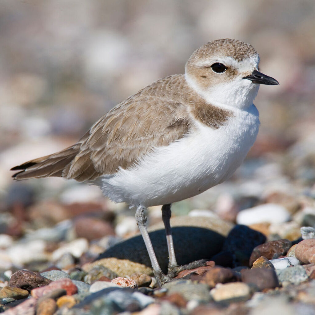
The Snowy Plovers breed on beaches and dunes up and down the West Coast, including Crown Memorial Beach in Alameda, and Eden Landing Ecological Reserve in Hayward, where Save The Bay conducts restoration. Like the Ridgeway’s Rail, the plovers are impacted by invasive species, including European beachgrass, which eliminates their nesting habitat. Both species’ critical habitats – tidal marsh and beach – have been lost due to residential and commercial development in California.
If you are interested in helping threatened bird species along the San Francisco Bay Trail, check out some of these nonprofits doing amazing work in the Bay Area: San Francisco Estuary Invasive Spartina Project and San Francisco Bay Bird Observatory.
West Oakland Environmental Indicators Project’s Shoreline Academy
Every day, anywhere from 6,000 to 20,000 cars pass through the community of West Oakland. West Oakland residents, tucked in between four major Bay Area freeways, are in the 99th percentile in the State for proximity to traffic and exposure to exhaust. This is just a small piece of the unfortunate saga of environmental injustice this community has been fighting for decades. West Oakland Environmental Indicators Project (WOEIP) is an organization leading the fight for environmental justice by empowering the residents to collect, analyze, and share data about the quality of the air in their community. Owning Our Air is WOEIP’s action plan to address poor air quality with 89 strategies from expanding Asthma Management programs and air filtration systems in community centers, to biofilter design and urban canopy planning.
This summer, WOEIP launched the first Oakland Shoreline Leadership Academy, another project aimed at community-informed solutions to environmental hazards threatening West Oakland. Save The Bay is honored to be part of the curriculum by leading a seminar on habitat restoration and ecosystem services of tidal marsh. Academy members will also participate in a restoration program located on the Martin Luther King Jr. Regional Shoreline. At the end of the 6 month session Academy participants will develop a community engagement plan and shoreline improvement project. Check out how you can get involved with West Oakland Environmental Indicators Project. Get involved!