Explore San Francisco and the Peninsula | Bay Day 2021
Bay Day Regional Spotlight


Brought to you by Facebook, weekly regional spotlights give an in-depth look at the Bay Area. From trails and activities to inspire your Bay Day Trail Challenge adventures, to partners and locations vital to Save The Bay’s mission of creating a healthy and resilient Bay – discover what makes our region so special, and so important to protect.
Don’t forget to follow us on Instagram and Facebook and share your adventure with #BayTrailChallenge #SFBayDay and tag @saveSFbay for the chance to win a $50 REI gift certificate every week in October.
Discovery Guide
Trails
Belmont Slough to Bedwell Bayfront Park
This hiking and walking trail is a 8.6 mile point-to-point trail near Redwood City that features a river and is good for all skill levels. At the tip of the peninsula there are observation platforms to view the wetlands of the Redwood Shores Ecological Reserve. The trail also passes through the Bair Island Ecological Reserve, a 3000-acre wetland complex, and ends with a two-mile loop in Bedwell Bayfront Park. →
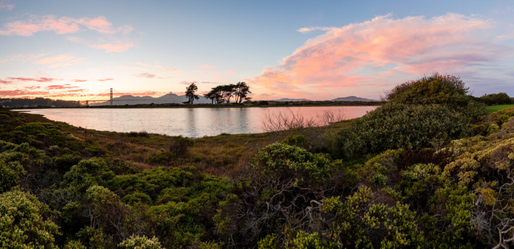
San Francisco Northern Waterfront
San Francisco Northern Waterfront is a 7.9 mile heavily trafficked and easy walking, running, and biking trail along the city’s waterfront. The trail begins at the iconic Fort Point under the Golden Gate Bridge and hugs the shoreline towards Crissy Field, passing restored wetlands and sand dunes. After passing through parks, harbors, and wharfs, the path reaches Oracle Park, where you can watch an inning for free from the stadium’s public viewing area. →
Activities
Climate Change and Human Impacts
Check out this video to learn more about how human-driven climate change is affecting the world around us, including San Francisco Bay. →
Quartermaster Reach and the Presidio Trust
Historically, the San Francisco peninsula did not sustain a great deal of tidal marsh habitat, but what did exist was largely altered and destroyed during the settlement and population growth of the Gold Rush era. Critical wetland restoration work, undertaken by the Presidio Trust and initiated with the renaissance of the Chrissy Marsh in the late 1990s, has reached a new phase in San Francisco.
The Quartermaster Reach project is a long-anticipated tidal marsh restoration project undertaken by the Presidio Trust, the National Park Service, and the Golden Gate National Parks Conservancy. Quartermaster Reach will restore seven acres of tidal marsh habitat adjacent to Chrissy Field. The project is the most recent piece of the multi-decade effort to restore the integrity of the Tennessee Hollow watershed, beginning with the El Polín Spring upstream and ending with output into the Bay.
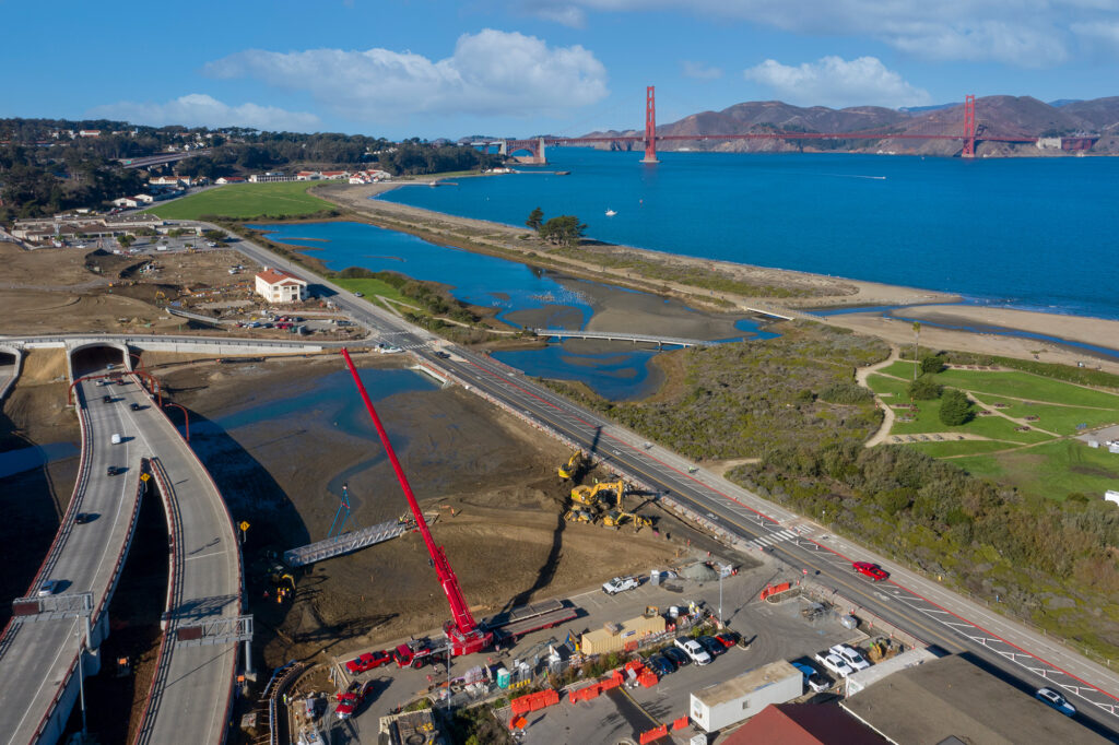
In addition to planting over 20,000 native saltmarsh and dune plant species, the restoration includes habitat creation intended to support the recovery of the native Olympic oyster. The restored Chrissy and Quartermaster Reach marshes provide rich brackish habitat for numerous native bay species including migratory birds, fish, and crabs. Footbridges and trails weave above and through the restored areas along the length of the watershed allowing park visitors to get up close and personal with these well-stewarded resources.
Sea Level Rise in San Mateo County
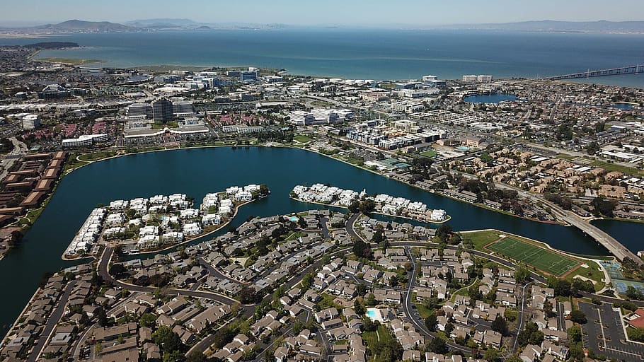
Given its location on the San Francisco Peninsula, wherever you are in San Mateo County, it seems like you’re never very far from the Bay. That’s partly what makes San Mateo County such a desirable place to live and work, but it also puts San Mateo at higher risk for future flooding due to sea level rise. In fact, San Mateo has more property (measured by value) and people at risk from sea level rise than any other county in the Bay Area. That includes regional infrastructure like the San Francisco Airport, large employment centers for some of the Bay Area’s biggest businesses, and individual homes that have been built on land that was once tidal marsh.
Luckily San Mateo County recognizes the risk and is already taking steps to make the county more resilient to climate change and sea level rise. Thanks to the strong leadership of people like Rep. Jackie Speier, Assemblymember Kevin Mullin, and Supervisor Dave Pine, in 2020 the county created the San Mateo County Flood and Sea Level Rise Resiliency District (OneShoreline). This is the first agency in the Bay Area specifically authorized to coordinate a county-wide approach to protecting people and property from future flood risk due to sea level rise.
This county-wide approach is crucial since the ability to plan and finance projects vary greatly by city, but flood protections can’t stop at the city limits. Despite being a hub for the Silicon Valley tech industry, some communities remain vastly under-resourced and vulnerable to climate change. A coordinated approach that plans projects with a regional focus is a step toward ensuring that all San Mateo County residents are protected from rising tides and that climate resilience in the county is more equitable. Hopefully, this is an approach that will be adopted by other counties around the region, allowing for a more coordinated and accelerated approach to protecting communities at risk for future flooding.
Working to Address San Mateo’s Housing Needs
The Bay Area is facing a housing crisis and needs to build significantly more housing to meet the needs of current and future residents. But where and how we build that housing is inextricably linked to our region’s approach to dealing with climate change. Save The Bay, though our Bay Smart Communities initiative, works to support housing development in ways that lessen the environmental impact of our cities, and promotes more resilient and equitable communities.
In San Mateo County, Save The Bay has partnered with the Housing Leadership Council to find ways to address these two crucial and linked needs. Over the past few years, we have co-hosted a series of workshops focused on identifying ways to meet our region’s housing needs while reducing greenhouse gas emissions, protecting people from current future flood risk, and easing development pressure along the shoreline and in undeveloped lands. Look for information on our next workshop hosted by HLC and in partnership with Greenbelt Alliance in early November.